Bike in Umbria
Route n. 1 Bike in Umbria
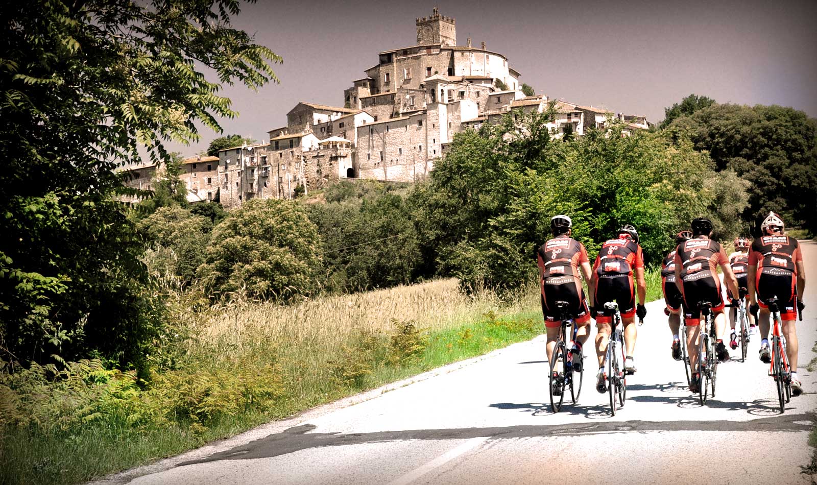
Lake Piediluco and the Marmore Falls
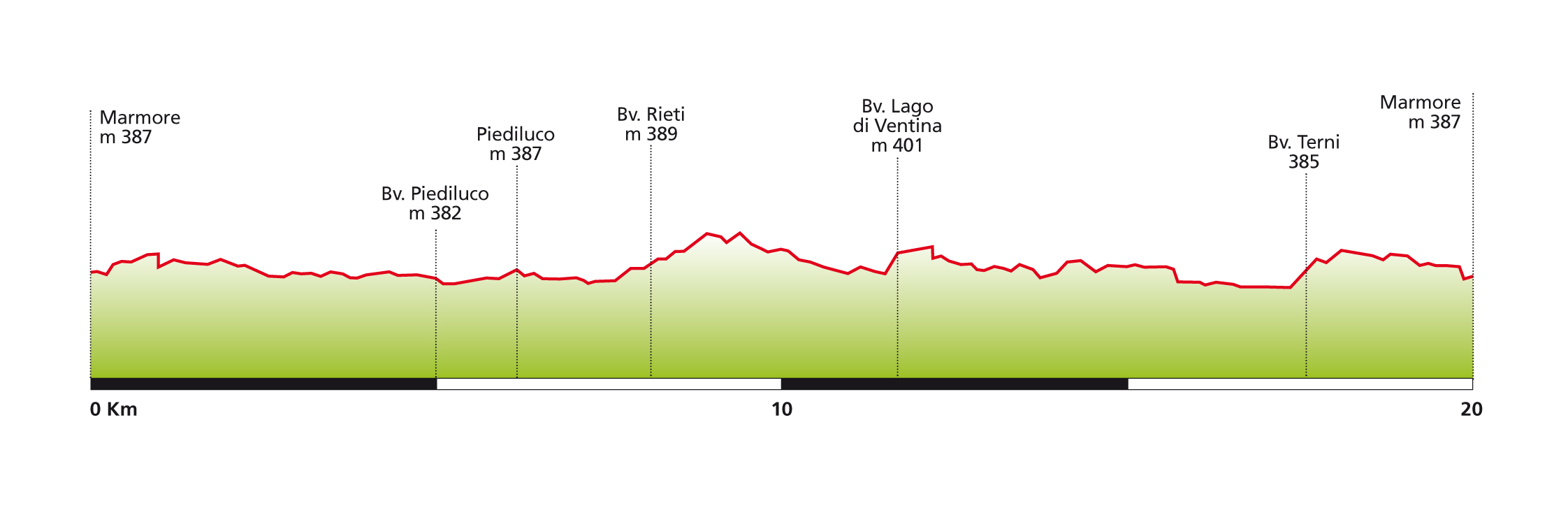
Technical Sheet
Starting and finishing point: Marmore
Distance: 20 km.
Total ascent: 150 metres
Grade: easy
Road surface: asphalt
Recommended type of bike: road or hybrid
Places to visit in the area: Marmore Falls, Piediluco village, Lake Piediluco, Papigno
Route no. 9 is a particularly easy one, being both short and fairly flat, but is also a very beautiful one, taking in the River Velino, the quiet waters of Lake Piediluco, and the majestic 165 metres-high Marmore Falls, which were created by Man in the year 290 BC, and channel the waters of the Velino into the River Nera below.
It is thus an easy, pleasant cycle ride through an area of considerable natural beauty, suited both to the more experienced cyclist who wishes to enjoy the superb views in peace and quiet, and to the most inexperienced of cyclists.
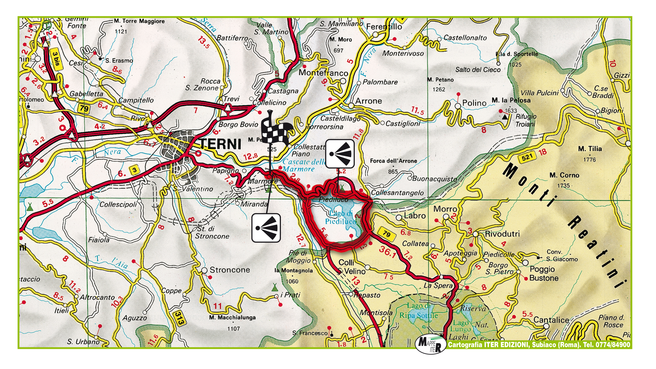
The route begins at Campacci Park, at Marmore next to the famous waterfall, and from here you ride out in a leftward direction towards Oiediluco, cycling on the flat alongside the River Velino.
At km.2.5, keep to the left and continue cycling towards Piediluco, and then at km.5 turn right, following the signs for the village of Piediluco once again, which you eventually come to another 500 metres further on.
The village is situated right on the banks of the lake named after it, and as such represents a great opportunity to take a relaxing break from your cycling and to enjoy the remarkable peace and quiet of this corner of Umbria.
From Piediluco (see ‘photo above left), famous for its traditionally colourful houses, follow the signs to Rieti, and at km. 10.5, turn right onto the SP4 towards Colli sul Velino. A kilometre or so of rolling countryside, take the turning to your right towards Lago di Ventina, and cycle along this quiet country lane in the middle of the lush green countryside, which leads to the lakeside opposite the village of Piediluco.
At km. 17 you come to a junction just after the bridge over the Velino: take the road to your left in the direction of Terni, and ride back along the same road you took on your way out towards the lake, a further 3 kilometres on and you are back at the starting point.
Route n. 2 Bike in Umbria
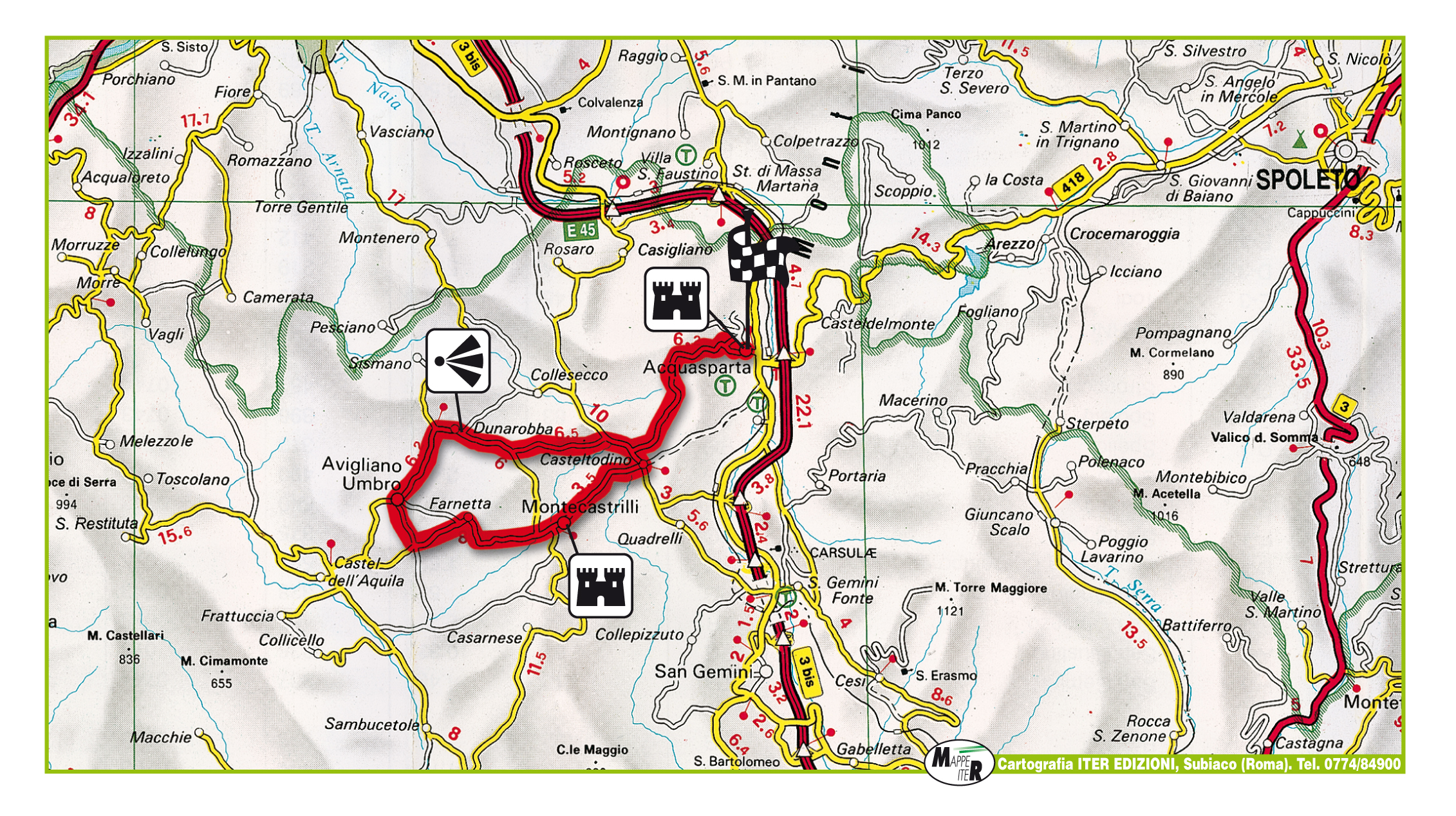
Acquasparta and the Roman ruins at Carsulae
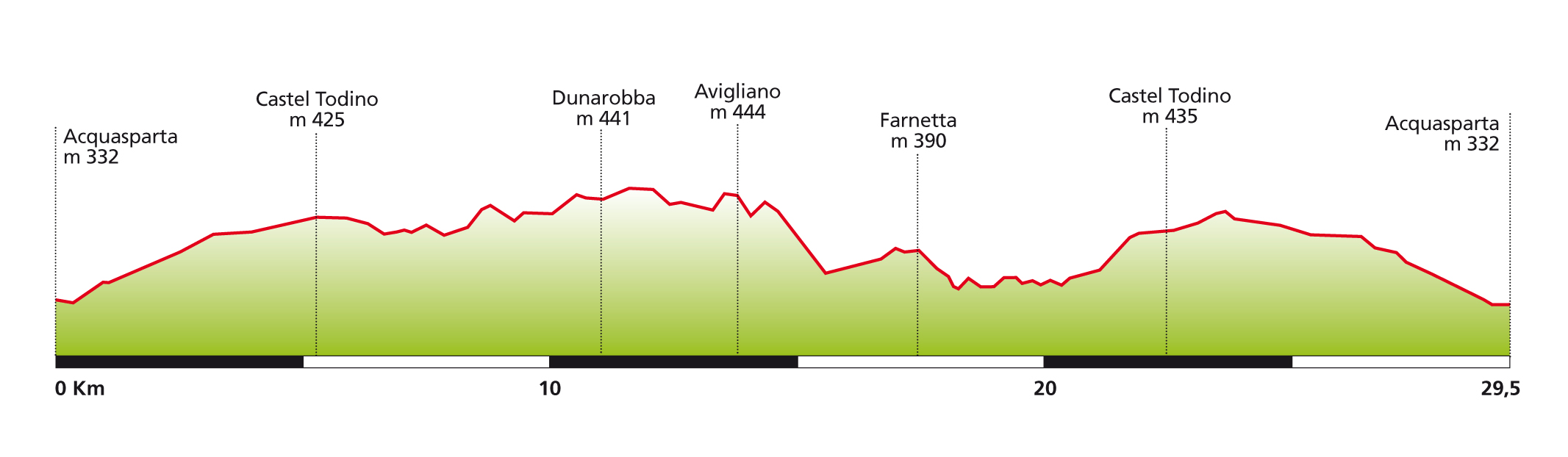
Technical Sheet
Starting and finishing point: Acquasparta
Distance: 29.5 km.
Total ascent: 350 metres
Grade: easy
Road surface: asphalt
Recommended type of bike: road or hybrid
Places to visit in the area: Acquasparta, Avigliano Umbro, Montecastrilli, the Fossil Forest at Dunarobba.
Route 7 starts from the centre of Acquasparta, an ancient town built on the ruins of the Roman settlement of Carsulae, and moves off across the winding hills towards Montecastrilli (see ‘photo above) and Avigliano Umbro.
It is an easy ride across softly rolling, peaceful countryside, with no real climbs involved, and is thus perfect for inexperienced cyclists who fancy a relaxing day’s ride.
The ride begins in Viale Roma, just outside of Acquasparta town centre, and from here you ride in the direction of Montecastrilli, along a slightly uphill section of road, for about 5 kilometres, taking you to Castel Todino.
Turn right here towards Collesecco, and less than one kilometre further on, turn left onto the SP81, in the direction of Avigliano Umbro and Dunarobba. This is the most panoramic part of the route, running as it does along a ridge affording splendid views of the surrounding countryside.
Continue following the signs to Avigliano Umbro, and at km. 10 you come to the Dunarobba Fossil Forest on your left: this is one of the most important palaeontological sites in the world, with fossilised tree trunks dating from three million years ago.
From here, carry on towards the village of Dunarobba, and once past the village, turn left towards Avigliano Umbro, where you may like to have a short rest before continuing on your journey.
From Avigliano Umbro, follow the signs to Farnetta and the sports ground, cross the centre of the village, and then turn right and ride downhill towards the junction with the SP82; when you reach the junction, turn left towards Farnetta and Montecastrilli.
Continue riding along through the countryside until you get to Montecastrilli at km. 20.5: from this medieval village you continue in the direction of Acquasparta, which marks the beginning of an undulating section of the ride which goes slightly uphill until you get to Castelo Todino (km. 23.5).
Continue following the signs for Acquasparta, which you get to after riding along a further six kilometres of undulating section, slightly downhill, at which point you can get something to eat and drink in the delightful town centre of Acquasparta.
Route n. 3 Bike in Umbria
Along the River Tiber to visit the WWF “oasis” at Lake Alvian
Technical Sheet
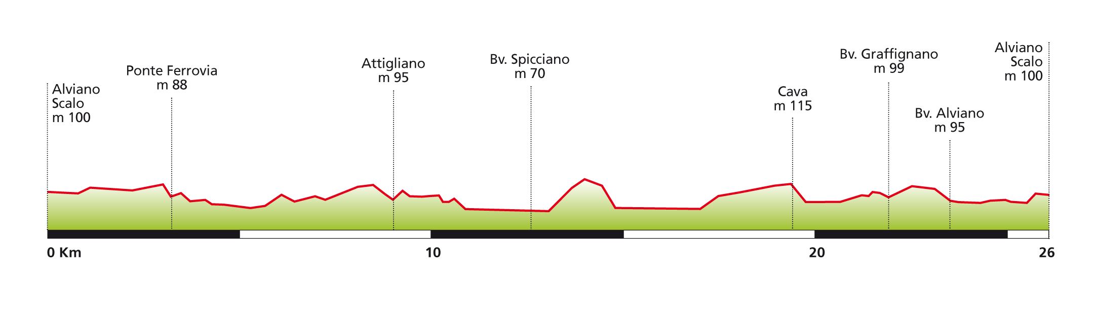
Starting and finishing point: Alviano Scalo
Distance: 26 km.
Total ascent: 300 metres
Grade: easy
Road surface: asphalt
Recommended type of bike: road or hybrid
Places to visit in the area: Alviano, Lake Alviano WWF Oasis, Attigliano, Guardea, Giove.
Route 10 starts from Alviano Station, and represents one of the easiest rides presented in this guide, being relatively short and almost entirely flat. It follows the course of the River Tiber along the border between the two regions of Umbria and Lazio, just a short distance from the World Wildlife Fund “Oasis” of Lake Alviano, a nature reserve of some 900 hectares that is extremely popular with birdwatchers.
Starting off from Alviano Station, you cycle in the direction of Attigliano and Viterbo, and after 400 metres, you leave the main SP11 road, and turn left onto a minor road through the open countryside, which leads to Attigliano (km. 9.5), a medieval village situated in the Tiber Valley.
From here, bear right and follow the signs to Bomarzo and Viterbo: as you cycle along this section of the ride, you will find yourself cycling for a few kilometres beyond Umbria’s borders, in the neighbouring Lazio region.
At km. 12.6, cross the bridge over the Tiber and turn right onto the SP19, in the direction of Alviano, Sipicciano and Castiglione in Teverina. The road is completely flat here, following as it does the course of the Tiber, and winds through woods and fields until you get to km.23, where you turn right and ride back along the road towards Alviano.
Another 3 kilometres on and you will be back at your starting point in Alviano: at this point, if you still have a little energy to spare, you could bear right and cycle the 2 kilometres up the hill to the centre of Alviano (the actual climb is quite short, but rather steep at times). Alviano is a small medieval town boasting a large 15th century Castle (see the ‘photo on the opposite page), and wonderful views across the Tiber Valley.

Route n. 4 Bike in Umbria
The natural beauty of the Amerini Hills
Technical Sheet
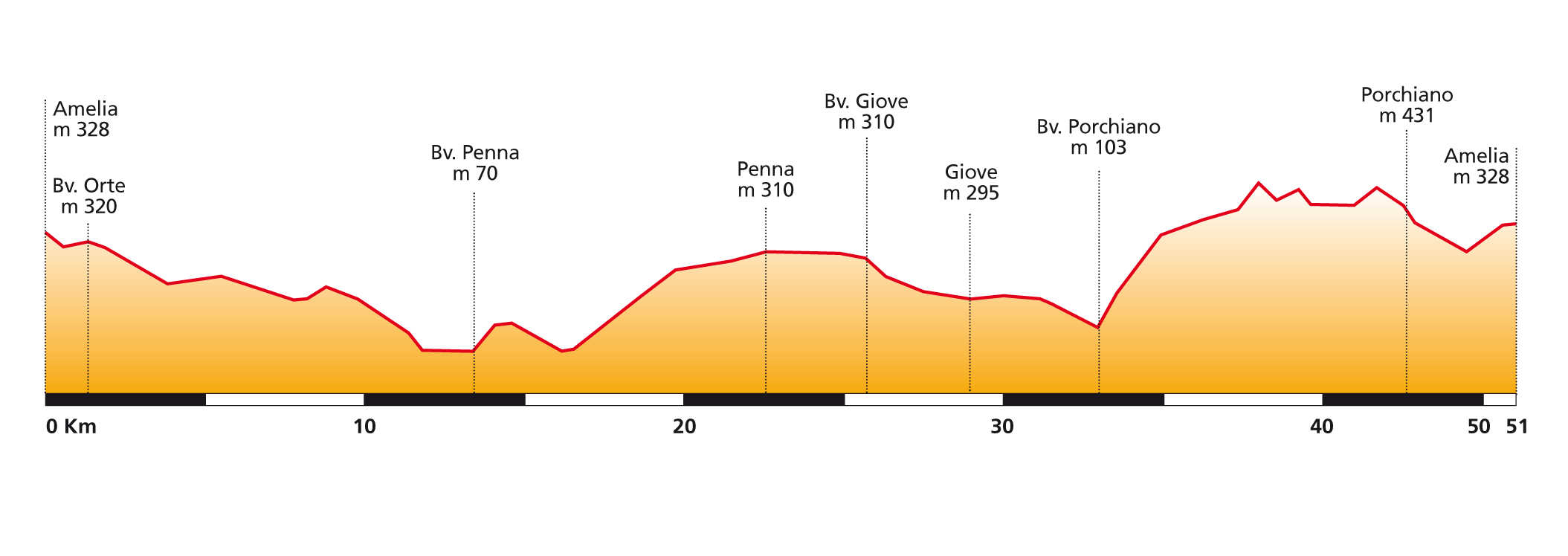
Starting and finishing point: Amelia
Distance: 51.5 km.
Total ascent: 1,000 metres
Grade: medium
Road surface: asphalt, gravel
Recommended type of bike: road or hybrid
Places to visit in the area: Amelia, Penna in Teverina, Giove, Porchiano.
Route no. 19 starts from the town of Amelia (see ‘photo above) and winds across the pure wild hills that separate Amelia from the Tiber Valley, passing through the medieval towns of Penna in Teverina, Giove and Porchiaro, and along beaten tracks in parts – reminiscent of a past age – which should be popular with those cyclists who use bikes other than racers. From the technical point of view, this route is undulating, with two significant climbs, namely the Penna in Teverina and Porchiano hills: albeit not particularly steep, these two climbs are rather long, and as such require a reasonable level of fitness and training.
The starting point is the public gardens in Amelia, just a short distance outside the town walls. From here, ride in the direction of Orte, and you soon begin a pleasant, winding descent down to the town some 13 kilometres further on. At km. 13.5, just before you reach Orte, turn right onto the SP84 in the direction of Penna in Teverina, which takes you through a very bucolic landscape amidst green hills and ancient woods.
Km. 18 marks the beginning of the 4.5 km climb up to Penna in Teverina. At the top there is a roundabout with a fountain where you can fill up your water bottle before setting off once again, this time in the direction of Giove to your left. The next three kilometres are across a magnificent plateau affording splendid views of the surrounding countryside.
At the next junction, bear left in the direction of Giove once again: this medieval town, situated at km. 29 of our route, has preserved its ancient walls and a number of the walls’ towers.
After a brief rest and a coffee, it is time to descend down to Attigliano; at the end of the descent (at km.33) turn right onto a gravel road which marks the beginning of the climb up to Porchiano (see ‘photo above).
The well-maintained gravel road is about 3 kilometres long, after which the road continues to rise in “steps” until you reach Porchiano, having gone across a couple of junctions, situated at km. 42.5 of the route.
Ride out of Porchiano, an ancient hilltop village situated in the middle of dense woodland, towards Amelia, and when you get to the junction with the SS205 (km. 44) turn right towards Amelia. The road back to the town is a winding one through the woods, but before going back to the town gardens, you may like to turn left and ride into the old town centre to visit its many artistic and historical treasures, including the Cathedral, the Church of St. Augustine, the Monastery of San Magno and the town’s beautiful 18th century theatre.

Route n. 5 Bike in Umbria
Narni, the Rocca Albornoz and the Roman ruins at Ocricolum
Technical Sheet
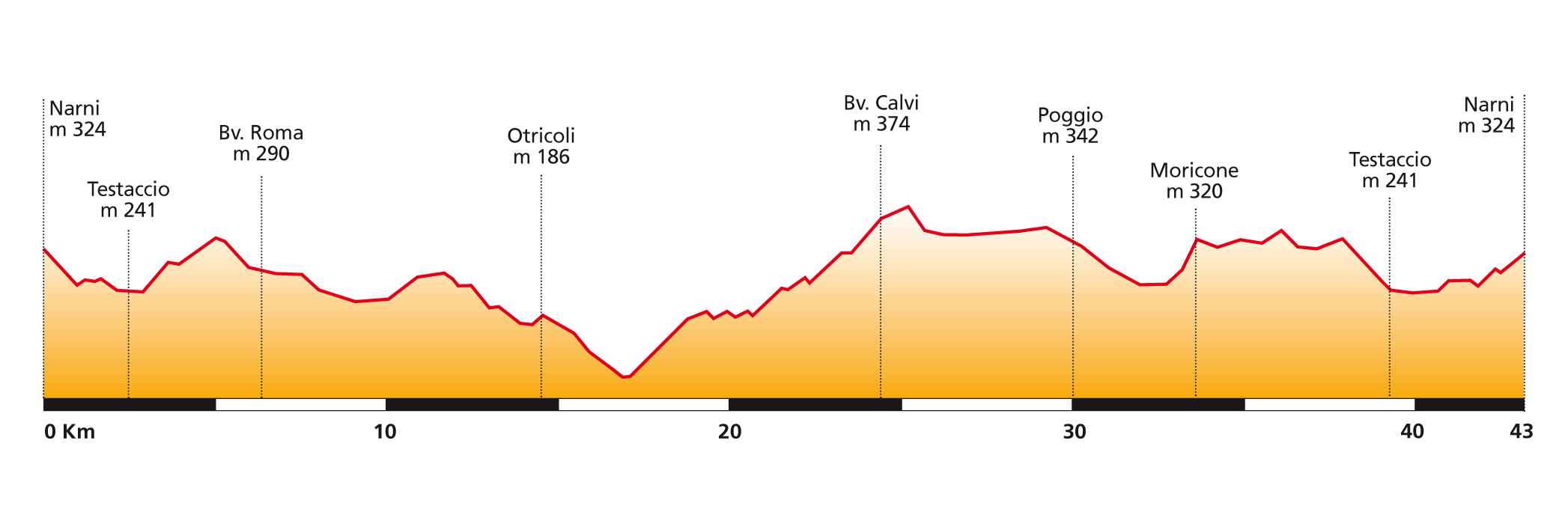
Starting and finishing point: Narni
Distance: 43 km.
Total ascent: 800 metres
Grade: medium
Road surface: asphalt
Recommended type of bike: road or hybrid
Places to visit in the area: Narni, Otricoli, Calvi, Poggio, Narni Castle.
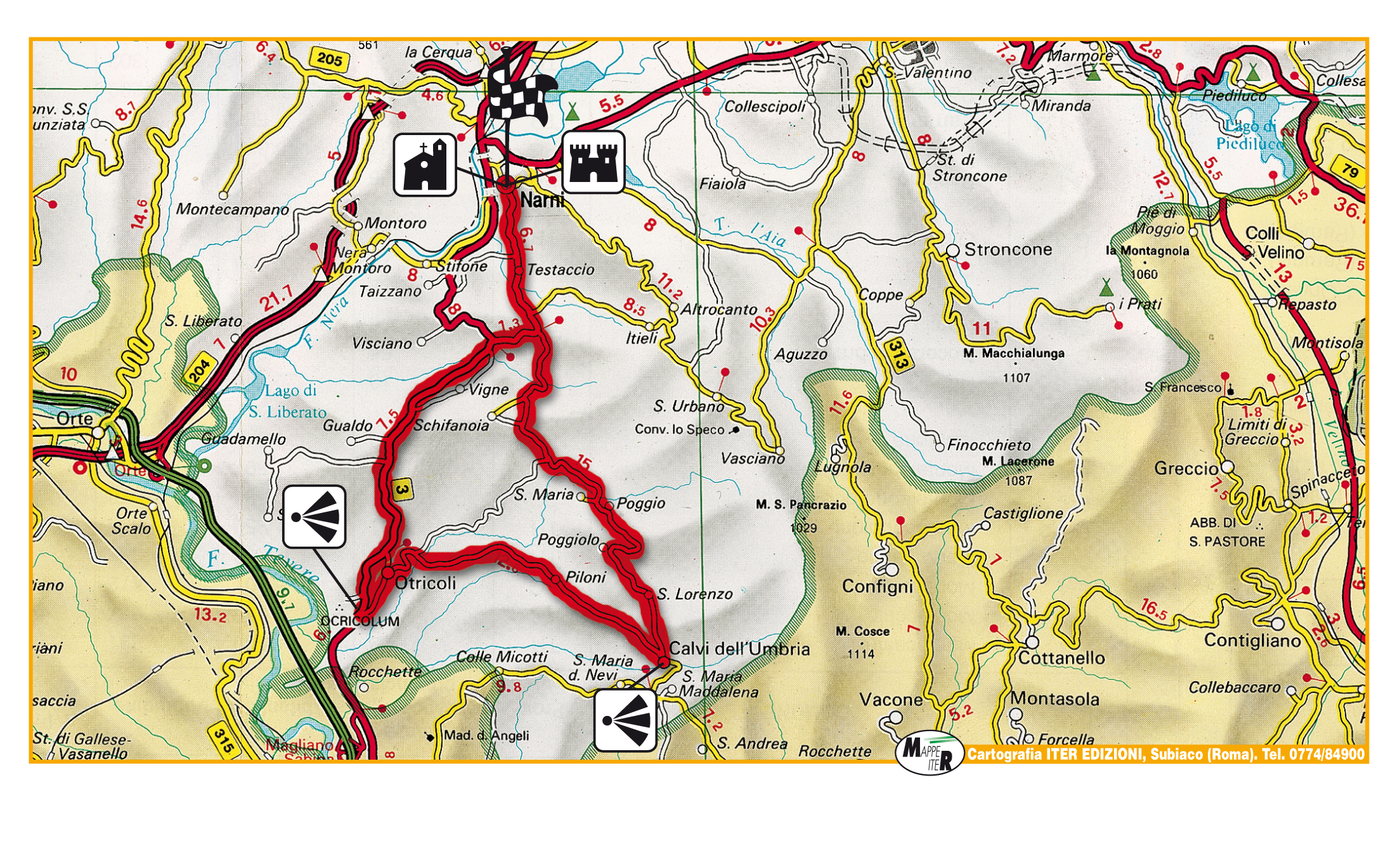
This route starts out from Narni (see ‘photo above), an ancient town dating back more mthan three thousand years, and conquered by the Romans in 299 BC under the name of Narnia. The town is situated among the quiet hills at the south-westernmost tip of Umbria, and the ride takes you to several other ancient towns and villages, such as Otricoli, Calvi dell’Umbria and Poggio.
The starting point is the Rocca Albornoz, an ancient outpost built midway through the 14th century at the very highest part of the spur on which the town was constructed. From here, you descend towards the centre of Narni and then turn left towards Testaccio, a small village 2.5 km. further on.
Carry on in the direction of Rome until you get to the junction with the SS3 (km. 6.5), and then turn left in the direction of Rome once again. Carry on along this undulating section of road until you get to km. 14, where you turn left towards the ancient town of Otricoli, famous for the archaeological zone of Ocricolum, the Roman town that arose along the Tiber in the vicinity of the Porto dell’Olio, the ruins of which mostly date from the Augustine age.
Once out of the town, turn left in the direction of Calvi dell’Umbria: after a descent involving a few hairpin bends you come to the beginning of the climb up to Calvi dell’Umbria (at km. 17) and after climbing for some 7.5 kilometres you finally reach the town, where you can stop for a rest and something to eat or drink. As well as numerous artistic works and historical buildings, the streets of Calvi also feature a number of murals depicting the Nativity, the work of famous Italian and foreign artists who, since 1982, come to the town to paint the walls of the old houses, hence its nickname as the “town of the Nativity”.
Leaving Calvi, take the SP18 towards Narni, and you will find yourself cycling through an almost unreal landscape of woodland and silence.
At km. 30 you come to the village of Poggio (see ‘photo above):carry straight on until you reach the junction with the SS3 (km. 37), and then turn right towards Narni, cycling along the same road you took at the beginning of the ride.
Ride past Testaccio, and you will come to the gates of the town of Narni at km. 42: but before turning right and climbing back up the hill to the Rocca, you must ride into the town centre and visit the many beautiful buildings and works it boasts, including the exciting visit to subterranean Narni, consisting of a series of aqueducts, cisterns, tunnels, crypts and even the torture chambers of the town’s inquisitional tribunal, complete with cell featuring the graffiti of those prisoners awaiting their sentence.
Bike in Umbria